


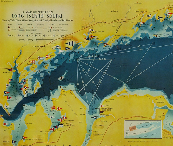
"A Map Of Western Long Island Sound Showing Yacht Clubs, Aids To Navigation, And Principal Larchmont Race Courses" 1939
$900
Classic color map/ nautical chart (by Nolf Klep '39) of the North Shore of Long Island Sound for members of the Larchmont Yacht Club (see verso)
Map Sz: 13 3/8"H x 21 1/2"W
Frame Sz: 18 1/2"H x 26 5/8"W
w/ nautical red matte & yellow lacquer wood frame
VG
Scroll Down for (7) Additional Pics:
Map, Long Island Sound, Yachting Club, Vintage Print, 1939
Rolf Klep (b. 1904)
A Map of Western Long Island Sound — Showing Yacht Clubs, Aids to Navigation and Principal Larchmont Race Courses
Fortune, Vol. 20, No. 2, August 1939
Photo-process print
14 x 22 inches
Decorative map of Long Island Sound, showing parts of Westchester County, Fairfield County, New York City, and the North Shore of Long Island. Yacht clubs indicated by flags. Lighthouses, buoys, radio beacons, currents indicated. Principal Larchmont Race Courses indicated by numbered white lines. According to the legend, “based on U.S. Coast and Geodetic Survey and Texaco Cruising Charts.” Issued in Fortune magazine to illustrate an article about the Larchmont Yacht Club.